Telematics provides advanced systems for tracking and managing fleets of vehicles as well as other mobile assets. Geotab is a global leader in telematics. Founded in 2000, the company now claims to have 3.2 million vehicles connected to its telematics units around the world. Geotab offers technology capable of collecting and analyzing vehicle data to help fleet managers make better-informed decisions. We met with François Denis, Geotab’s CEO for France, to find out more about how fleet tracking can help businesses save money from route optimization to driver safety.

One of the key advantages of telematics in fleet management is the ability to track and monitor the geolocation and status of vehicles in real time. This can, for example, help fleet managers optimize routes, reduce fuel consumption and improve overall efficiency. Additionally, telematics can help monitor driver behavior and performance in order to improve safety and reduce the risk of accidents. With the ability to analyze data from multiple sources, telematics can also help fleet managers make more informed decisions about vehicle maintenance and other operational issues. Lastly, telematics can provide significant cost savings and operational benefits for companies that rely on a fleet of vehicles for their business.
In an interview with DirectIndustry, François Denis, Geotab’s CEO for France, gave us more details about their telematics technology and how it is giving fleet managers insights allowing them to make better decisions.

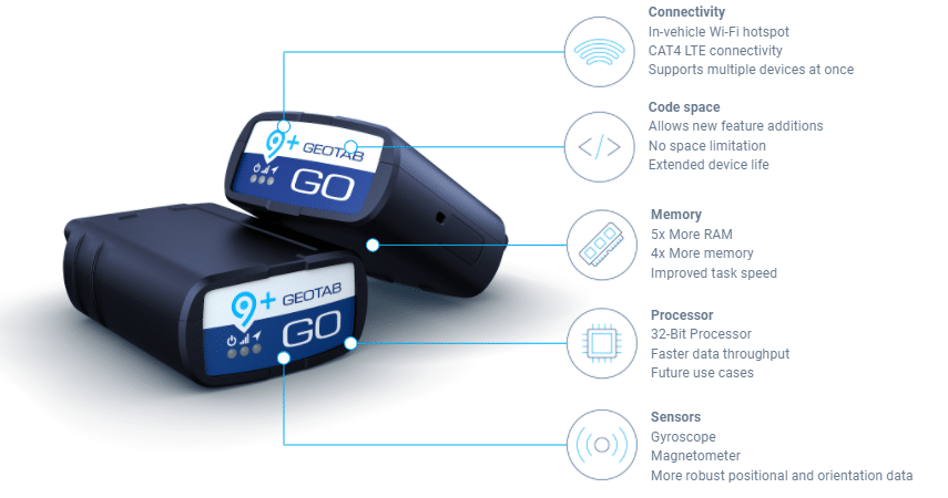
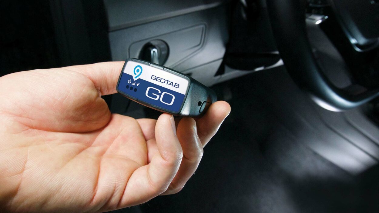
Geotab manufactures boxes to be installed in vehicles to collect data. What kind of data are we talking about?
François Denis: “The idea is to connect vehicles to the Internet in order to collect 4 types of data.
First is the data of the vehicle itself. We connect our box to the OBD (onboard diagnosis) of the vehicle. This plug enables the diagnosis of a vehicle in a workshop. And from this plug, our box will be able to read the data of the CAN bus such as the mileage and fuel consumption.
Then there’s the driver’s driving behavior: our box is equipped with a gyroscope and an accelerometer which allow us to know how the driver behaves when driving.
Our box is also equipped with a 4G LTM SIM card and has a side socket that allows other peripherals to be plugged in to retrieve other types of information. For example, road haulage vehicles can connect a tachograph. The box can also be connected to the refrigeration unit of refrigerated vehicles to manage the temperature remotely. It is also possible to connect a camera to see the road or to film the inside of the vehicle.
And lastly there’s GPS data. All our units are equipped with an antenna and a GPS module that allow the geolocation of the vehicle.
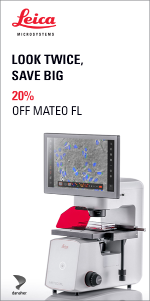
We only have one kind of box, the GO 9, for all vehicles, whether they are light vehicles, commercial vehicles, trucks, buses, coaches or even construction equipment. In this last case, the box is ruggedized to be able to function in more difficult conditions.
Once plugged in, the box automatically recognizes the vehicle, searches for the VIN number and finds the corresponding firmware.”
How is the data collected and what can it be used for?
François Denis: “The data can be collected in 2 different ways: either on the mygeotab platform or through an API. The advantage of API is that it allows, for example in the field of transport, to bring up driving times on a prepayment software.
There are many use cases for the data beyond mileage and consumption. As soon as all the data from the CAN bus is retrieved, it is possible to determine when the car was last serviced and when the next service is due. This also allows us to know when maintenance should be carried out, because the alerts are sent to the platform and can therefore indicate to the manager which vehicle should be taken off the road and sent for repair, for example.”
Why are fleet managers opting for telematics?
François Denis: “The first reason is to save money. The ROI is very fast when data is used intelligently. For example, it has been determined that the difference in fuel consumption between the best driver of a fleet and the worst driver is 35%, which is enormous.
The second reason is safety. Monitoring the driver’s driving behavior will allow the driver to be sent on a driving course if he or she is in need of correction. Good driving can also reduce the insurance premiums for the owner of the fleet . And of course it is also part of the corporate social responsibility of the company.
Lastly, it helps each manager handle their own specific area, for example managing the cold in the case of refrigerated vehicles.”
With the arrival of EVs that no longer use the OBD-II standard, how will you adapt your boxes?
François Denis: With EVs, there is no obligation to use the OBD-II standard which was designed for the ICE (Internal Combustion Engine) vehicles. The box is plugged into the standard diagnostic socket, and we have to do some reverse engineering work to be able to find ways to talk to the EV and send back the data. So as soon as an electric model arrives on the market, our engineers explore the CAN bus, interpret it and send a version of the firmware to the box that will talk to the vehicle. Each type of electric vehicle has its protocols so it is a lot of work, but we manage to do it. The hardware remains the same.”
But wouldn’t it be in the interest of car manufacturers to integrate telematics boxes directly into electric vehicles?
François Denis: “This is becoming more and more common. Car manufacturers of thermal or electric vehicles are increasingly integrating a box into their vehicles on the factory floor. We have been talking to them for some time now about uploading the data from their boxes to our platforms. Because these boxes are often quite simple. They don’t have accelerometers, for example.”
Your boxes work in 4G today. How often is the data collected? What about 5G?
François Denis: “With a classic fleet management system, we regularly collect data via an algorithm. For example, if you are on the highway and you don’t change your driving style and speed. If you leave the highway and turn, the algorithm detects this change and enters the new data.
We are very stingy in sending data. Data is only uploaded when it is smart and makes sense to upload it.
On the other hand, for the emergency intervention vehicles that we also equip, such as police or firefighter vehicles, we use live tracking. Data is constantly being uploaded for the emergency.
5G will be a big advantage for the speed and quantity of data transmitted. But it will be mainly available in big cities, not in the countryside. We don’t see the need to be on 5G yet. Eventually it will happen. Today, LTM is sufficient to retrieve data even in live tracking.”
In terms of cybersecurity, as cyber attacks are becoming more and more frequent on connected object, what kind of protection do you provide?
François Denis: “We have developed a maximum level of security with the US Army. We are the only company in our field approved by the US government, for example. The US Air Force is one of our customers for its ground vehicles. We have the Fedramp security level. And it is this same level of security that we incorporate in our box.”
What other applications does telematics allow?
François Denis: “From all the data we have collected, anonymized and aggregated, we can help municipalities. In the USA, we have developed an ITS (intelligent transport solution) to advise municipalities on the timing of low beam lights, for traffic, because we have sufficient volumes of anonymized data to have an idea of where vehicles are.”